Search This Blog

Saturday, April 28, 2012

Tusten Mountain Trail: Upper Delaware Scenic & Recreational River


Looking out from the Tusten Mountain vista.

Most of the Delaware River from northeast Pennsylvania border with New York to just south of the borough of Delaware Water Gap falls under the jurisdiction of the National Park Service. The Upper Delaware Scenic and Recreational River covers the northern section while the Delaware Water Gap National Recreation Area presides over the southern part. In addition to the actual “river” the “Water Gap NRA” has an extensive collection of trails for biking, equestrian use, and hiking. The “Upper Del” is not so fortunate. The vast majority of the land abutting the river is private and hiking opportunities are scarce. There are a few areas of note for woodland ramblers to check out, one of which is the Tusten Mountain Trail.
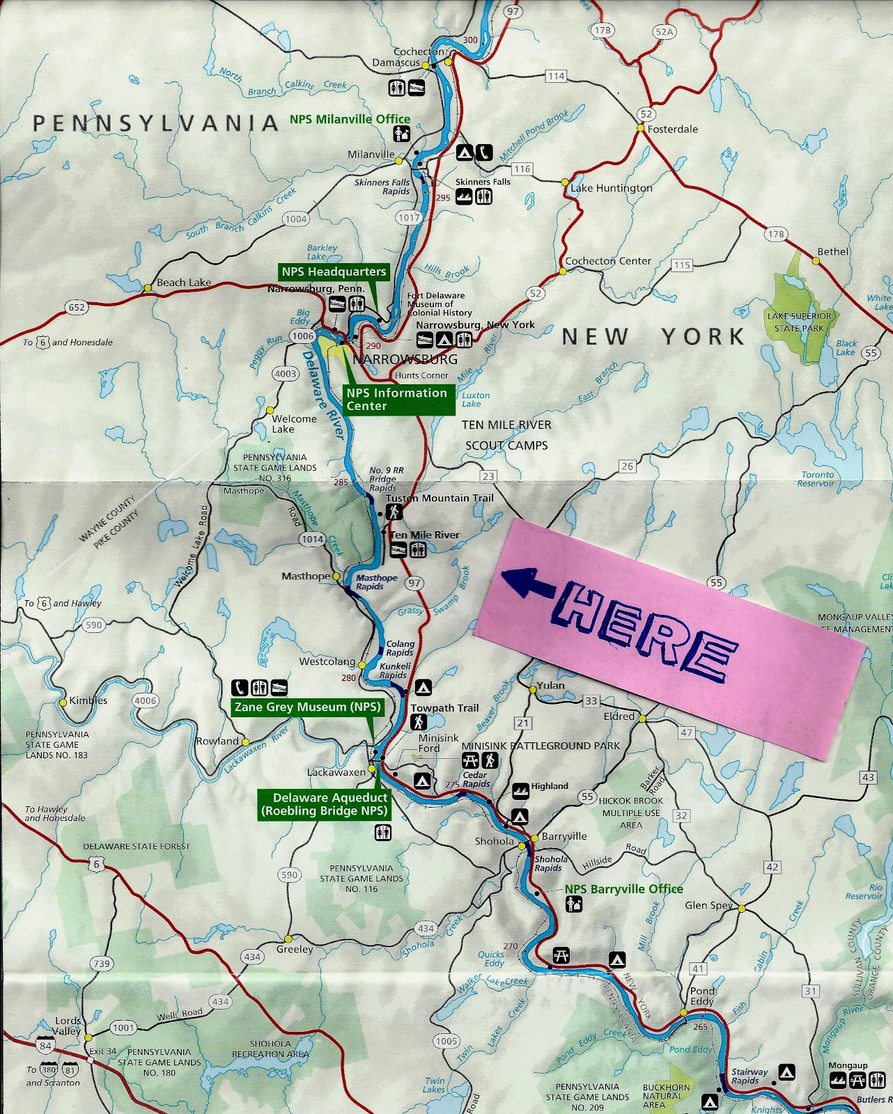
Located about halfway between Narrowsburg, NY and Lackawaxen, PA, the Tusten Mountain Trail is a three-mile loop that offers a nice view of the valley as well as a wide array of other natural and manmade things to investigate. While not lengthy, it is definitely a moderate hike due to some steep sections as well as some rocky (and in winter, icy) terrain.

Park Service map. Note marks parking area.

The trailhead is rather easy to find. Simply park at the Ten Mile River boat launch and look for the kiosk. Maps for the trail, provided by the Park Service are generally available there. The trail is located on private land owned by the Greater New York Councils of the Boy Scouts of America and is situated within the Ten Mile River Scout Camps approximate 14,000 acres. Several scout tent sites and lean-to areas are located along the trail. Please be respectful of the property and friendly to any scouts or other hikers you may encounter. This area of the scout camp is primarily used for weekend camping by scout troops that are canoeing on the river and for hiking. Additionally some weekday encounters with scouts can be expected in summer as this area is sometimes used by older scouts on multi-day backpacking treks. The campsites are available for use by scouting units, but are not open to the general public.


The trail officially begins at the kiosk and follows the dirt road along the Ten Mile River for a short distance before coming to a stone bridge. The bridge was constructed in 1875 and is a favorite subject for artists and photographers. Immediately after crossing the bridge are some ruins. Reeve’s Mills and Tusten were former villages that used to occupy this area. Here the trail gradually begins its ascent, still following the road for about another 0.4 miles. An abandoned quarry is visible on the right side of the road in this section. Immediately across the road is an old tailings pile from the quarry. Presumably, quarried stone was loaded onto sleds or carts and taken to market; the scrap was pushed to the side and left in piles. This is one of many tailings piles and quarries that dot the entire mountain. After a little bit, the road makes a quick descent. There is a large boulder on the right side of the road and a small vehicle turn-around to the left.


Here, turn right and proceed about 100 feet to a sign-in box. After signing in, hikers can choose to proceed directly to the summit by taking the left fork on the yellow trail or opting for a longer ascent on the red trail. The yellow trail rises sharply with only two short, flat sections. It involves some scrambling near the top. The red trail is rather flat until it meets up with the other part of the yellow loop. From the yellow/red intersection the trail is fairly gradual until it meets the cliff and then it gets rather steep and sketchy. Regardless of which way one takes to the top, crossing through this terrain will be necessary in order to complete the whole loop. Similarly, side trails and intersections can be found no matter if one hikes the loop clockwise, or counter-clockwise. Anyone hiking here should be wary of these side trails as some are not blocked off and a few lead miles away from the area. Others lead to private property and few, if any are marked or show up even on satellite maps.
Some notes attached to the official BSA map for Ten Mile River Scout Reservation.

The summit area has a great vista that overlooks the river. Several large slab rocks are perfect for a picnic or just a quick rest. Immediately below the summit is another old quarry and is worth exploring, but use care. A number of other quarries can be found in the way down from the summit by following the loop clockwise. Anyone hiking the trail in a counter-clockwise manner will encounter the other quarries on the way up.
Wintertime trekkers up Tusten Mountain should be prepared for ice. Snowshoes are not always needed, but boots and some sort of cleat (Yak-Trax, Kahtoolas, etc.) are suggested. Similarly, melting snow can make the trail muddy quite often throughout the winter. Rain runoff and seep make parts very muddy the rest of the year. Boots are not needed in warmer months, but they are not a bad idea.

Turkey and upland game birds are frequently seen in the area. Vultures are a common sight from the vista and eagle watchers should be on the lookout closer to the river. There are a number of Poplar trees in the area as well. Their white blossoms can frequently be seen in the spring along with Bluets, Violets, and Red Columbines. Great Rhododendrons also grow in the area along with Mountain Laurel. Due to the summer canopy, these bushes usually do not bloom. If they do, it is generally later in June and early July. Of course autumn is a wonderful time to explore this trail as well. There is a wide variety of hardwood trees on Tusten Mountain and each yield different hues from late September through the end of October. Although the trail is closed for a two week period during deer hunting season in late November and early December, Tusten Mountain offers something for every hiker year round. 

Tusten Mountain Trail Information: http://www.tusten.org/TustenTrail.htm
Ten Mile River Scout Reservation: http://www.tenmileriver.org/
Upper Delaware Scenic and Recreational River: http://www.nps.gov/upde/index.htm

Mad River Glen: Ski It If You Can


I ski MRG at least once a year and have been doing so for over 10 years. MRG is not a flashy resort with tons of amenities. It does not allow snowboarding. The single-chair lift can have a long line. Trail grooming is minimal. Snowmaking is done by The Almighty. The trails are narrow, steep, and sometimes littered with moguls. These qualities would be a turn-off to most would-be skiers, to MRG devotees, these are the exact reasons this mountain is beloved. In order to appreciate this resort a skier must eschew modernity and embrace skiing as it was before steel framed lodges with drywall interiors, high-speed six-pack lifts, and groomed trails wider than a freeway.

My buddy, Tony riding the Single Chair

 Whether you ride the Single or the fixed-grip double to one of the two top stations, your choices about how to get down are numerous and the difficulty level ranges from a couple of green trails that traverse the resort, to a myriad of straight shots that will have you dodging trees and sketchy sections the whole way. I like to start by warming up on Upper Antelope before cutting over to The Upper Glade, Ferret, or Moody's, and then ski out the Lower Glade. After that, the rest of my day usually is consumed by seeking out trees, chutes, and bumps with occasional journeys into the green terrain when I need a break.

Lower Glades
MRG is not all bumps and trees. In fact, the entire skier's left side of the the lower resort is consumed with oodles of twisting greens and blues reminiscent of a Snakes and Ladders board game. Not only are these fun runs that can be used to access some great off-piste terrain, but these trails are perfect for the kids and beginner skiers. A mid-mountain double serves this area on busier days. Another double serves the somewhat separated learning area. I often wonder what it's like to be a kid here and grow up skiing this mountain. I hope the kids appreciate it.

My friend John, gingerly entering a chute

With no big amenities, there isn't always a lot to do for apres-ski. Good local acts do play in General Stark's Pub. They also serve some excellent dishes and have a nice selection of local brew. Snowshoe trails also exist for those who want something other than skiing.

Lynx trail

 MRG's snowboard ban is perhaps it's most controversial issue. Knowing the history of the resort and the reasoning for it I support the ban to a certain extent, but I know a lot of snowboarders who would love to ride the trails here and are good enough and respectful enough to do so without it being an issue. Instead of snowboarders, MRG attracts a higher-than-usual amount of skiers that use telemark equipment. This anachronistic manner of skiing is just as throwback as the mountain itself, and thus embraced by the resort. It's just another thing that gives MRG a certain flair not found at any other resort, and yet another reason I keep coming back.

Mad River Glen: http://www.madriverglen.com/ (802) 496-3351


The iconic MRG bumper sticker


Friday, April 27, 2012

Autumn Adirondack Adventures


Heart Lake at the Adirondak Loj

The first time I laid eyes on the Adirondack Mountains I was nine years old. My family took a vacation there prior to my cousin’s wedding in Schenectady. I don’t remember much about that trip aside from taking a boat ride down the Ausable Chasm. Back then they had wooden boats (I think) and nowadays they use rubber rafts to navigate the two mile gorge. I also remember riding the chairlift up Whiteface Mountain with my mom. I’m not sure if that chairlift is still there today. It probably was replaced by the Gondola, and given that ski-history is somewhat of a hobby of mine, you’d think I’d know, but that ride was long before I started skiing and even longer before I started taking note of the annual changes to various ski areas throughout the Northeast….but I digress. When we got off the lift I remember looking up to the summit and being disappointed that it didn’t go to the top of the mountain. I also recall seeing the other High Peaks of the region off in the distance and being amazed by them. I had been to the Smokies two years before that and had taken a tram ride to the top of one of those mountains as well, but something about these mountains were special. They were dramatic.

The next time I would visit the area would be six years later, this time to hike with my scout troop. I had already climbed big mountains out west by this time, yet as we approached the Adirondak Loj I peered out at the peaks with awe. We climbed two mountains that trip, two more the next year, and then I climbed a few more with my college outing club a few years later. One peak I didn’t scale was Mt. Colden, the eleventh highest in the Adirondacks. My first attempt to climb it was in 1998 but I was ill prepared for the six inches of snow that remained on the trails in late May. A second attempt was made in 2003 but was thwarted by a thunderstorm. Hopefully this trek would be successful.

I convinced my wife that a camping trip would be a good idea. I hadn’t been to the ‘Dacks since my climb up The Wolfjaws (see the earlier past about that trip) and the two of us hadn’t been camping in a long while. We weren’t roughing it by any means. Sure, we were tenting, but we were staying at the Loj campground. Lake Placid’s amenities were only a ten to fifteen minute drive or so away. On the way up we made the obligatory stop at The Loft in Lake George for a burger. The Loft is strategically placed just off the Northway and I must pass it going to both the Adirondacks and northern Vermont. Not stopping is not an option. After munching on the monstrous mix of meat, cheese, onions, and mushrooms we continued northward. Next we were getting off the exit for Route 73 and began making our way up the Keene Valley. It was late September and the area had just been hit hard by flash floods from hurricane Irene. Debris still littered the roadsides and creekbeds still showed signs of recent overflow and erosion. Even the road to the Loj had taken a hit. Thankfully the campground was intact and open for business.


Rather than deal with cooking we chose to dine out at the Lake Placid Pub & Brewery. I eat here almost every visit. The beers are excellent, the service is great, and the food is delicious. I suggest the ribs, and I suggest getting there early if you want them. When the daily supply is extinguished that’s it. If the weather is conducive to al fresco dining, opt for the deck and enjoy a meal and some fine ale watching the sunset over the peaks while last rays of light play on the waters of Mirror Lake. After dinner we headed back to camp in preparation for some hiking the next day.

Rocky Falls
My wife isn’t much of a hiker. Tackling an Adirondack High Peak was something she wasn’t going to do, but she wanted to hit the trail so we opted for a short, easy hike out to Rocky Falls. For late September, it was rather warm. Evidence of the storms was present as the trails were still muddy in places, but things overall were in good shape. Perhaps this was an omen of good things to come on my planned pitch up Colden the next day. After our morning hike we headed back into town for some lunch and then made our way over to Tupper Lake to visit The Wild Center solely so we could see the otters. The Wild Center is geared for kids but suits childlike 30-somethings equally as well. This was my second visit. We partook in some Italian food for dinner, so I carbed up on Alfredo at Nicola’s before calling it a night.

Day three started early for me. My wife slept in and had a day planned at one of the spas. I was going up. My hike began the same way as it had a dozen times before. A well-trodden two mile stretch of trail serves as the main thoroughfare leading from the Loj to the High Peaks. It’s a fairly level trip to Marcy Dam and I made good time. I was met with one detour just before the dam. The trail had been wiped out at the dam and the course was rerouted over some rocky sections of the creek. I was able to rock-hop without event but was rather shocked at the state of the dam and the lake. Irene had shown her wrath to the area. I lingered for a moment or two taking in the damage but also the fall colors. I also consulted my map. A bunch of trails merge here and lead to various peaks and camps, but they are well marked and choosing the correct one was not an issue.


Now the climbing started. Gradually at first, but little by little the incline increased. Here still the trail was in good shape and showed signs of regular use. I had been passed by another hiker very early after leaving the Loj and a few were just in front of me when I got to Marcy Dam, but they had all headed in other directions. I stopped for a quick break at a trail shelter just before the split to Lake Colden where a DEC Ranger passed me. He too was not going my way. It was 10:00am and I was pretty sure I was alone. The route I chose was not a popular one. Most hikers attack Colden from the campground at Lake Colden. I was taking the Lake Arnold route.

Before heading out I made sure the trail was open. There were still a few trails closed due to storm damage and I knew the Arnold approach was not a priority for the Rangers. Even the folks at the information center could only give me sketchy reports. Of course they told me the trail was sketchy all the time. Being a seasoned ADK hiker, I’ve come to prepare for sketchy. As I climbed higher my pace slowed. Not only was the trail getting steeper, but after the split for Lake Colden it became significantly rockier and at points ran concurrent with a stream bed. This proved to be the norm rather than the exception, but I eventually made it to Lake Arnold without much difficulty. I stopped for a snack and reloaded an empty water bottle before pressing onward. I could see the summit now, but the path snaked around to the other side of the mountain and it faded from my view.

Lake Arnold
The next leg was rather interesting. Flat areas were flooded and I found myself up to my knees in mud on several occasions. In many places the puncheon was under water or simply gone. My guess is even before Irene made her visit this section was in need of some maintenance. There were a few downed trees here as well, but only one forced me off the trail. Soon I encountered the sign notifying me I was entering the Alpine Zone (always a welcome thing) and shortly thereafter the trees began to shrink and then disappear altogether as I crested the north summit. I was tempted to linger here, but I had to press on. Descending only to have to go back up is always disheartening but the last push up to the summit wasn't as painful as I thought it was going to be. Of course in the back of my mind I knew I’d have to come back this way. It was later than I planned to be where I was at so taking the longer route down to Lake Colden and out Avalanche Pass was not an option. I was past my turn-around time and didn't want to gamble with unfamiliar trail. Sadly, there wasn't much time to take in the panorama.

Mount Marcy from the Colden Summit

The return trip was uneventful but memorable. Even though gravity was helping my descent, it was slow going at times. Downclimbing bare rock I scrambled up earlier could now prove to be hazardous. It always is. Fatigue, plus the laws of physics, can lead to a bad fall and the long haul downhill takes a toll on the knees. As I made my way lower and lower the shadows of the afternoon began to bend the light as it hit the trees. The canopy was a palate of fall colors and changed often. It reminded me of Prince Prospero’s palace in The Masque of the Red Death, the foliage filtering the light like the stained glass windows in Poe’s story. I arrived back at the shelter where I had seen the Ranger earlier in the day. A hundred yards below that I ran into the first humans I had seen in just over seven hours. It added to the surrealness of the situation. This was my first solo ascent of an Adirondack High Peak and my first ascent of anything by myself in a number of years. I stopped by Marcy Dam again for a bit and enjoyed my last few minutes of solitude. In forty minutes I would be back in camp.

Fall Colors at Marcy Dam Lake
When I made it to my campsite I found my wife napping. She enjoyed her day at the spa. I cleaned up and we headed out to town for dinner at the Great Adirondack Steak and Seafood/Brewing Co. One more night in the tent and then it was time to slowly head home via North Creek and Cooperstown, but that’s another story for another day.  

Thursday, April 26, 2012

Spring Hiking in Northeastern Pennsylvania


View of Lake Wallenpaupack along the Shuman Point Trail

Springtime is a great time to hit the trails in Northeastern Pennsylvania. The days are generally not hot and sticky; squadrons of insects are generally not out en masse; the birds are back from their winter havens; and wildflowers begin popping up throughout the area. Whether you are out for a long day hike deep into the Delaware State Forest, or just taking a quick jaunt up to the views overlooking Milford, there’s plenty to see and experience for anyone whether a novice hiker or a seasoned veteran.

View from the Cliff Park Trail in the Delaware Water Gap NRA
Where I hike varies greatly throughout April. Early in the month I’m prone to venture into the Delaware Water Gap National Recreation Area or Ricketts Glen State Park to check out the waterfalls. Those April showers, coupled with the runoff from melting snows swell the streams and boost the water volume that tumbles over the escarpments. While the most popular falls inside the Delaware Water Gap can be reached easily via boardwalks and well-used trails, journeys to places such as Adams Creek Falls and Indian Ladders, both in the recreation area and accessible off US-209, require waterproof hiking boots with good traction, as does hiking at Ricketts Glen.

Adams Creek Falls in the Delaware Water Gap NRA 
If I’m in the mood to look for birds I generally head to the Bruce Lake Natural Area just north of Promised Land State Park. While some of the trails can be a bit rocky, most of them are relatively flat and open allowing the birding hiker the luxury of walking quietly and not having to keep looking down for rocks and downed limbs. The woods are fairly open so spotting songbirds is not too difficult and the trails skirt the edges of two lakes so waterfowl and pipers can also usually be found. Additionally, the dam and spillway constructed by the Civil Conservation Corps in the 1930s is worth checking out.

Inside the old barn at Varden Conservation Area
Old buildings and abandoned farms are another thing I like to seek out and early spring is a great time to find those things because there’s no snow cover, overgrown vegetation, or freshly fallen foliage to hide them. Easy scores can be found at the Varden Conservation Area while harder-to-find ruins lurk in the woods of Prompton State Park. Additionally, the trails at Prompton State Park run right along the Lackawaxen River, which is usually stocked with trout. Deeper into the park one can find some tiny holes where native trout hide out. So pack a fishing pole once trout season rolls around. At about the same time, Prompton’s wildflowers start to explode. Violets and Bluets will dominate the forest floor well into June, but the Trillium and Columbine that bloom only stick around for a short while. The State Game Lands off Masthope Plank Road between Welcome Lake and Lackawaxen also offer easy, creekside trails ideal for viewing flora or casting a line.

Trillium in bloom at Prompton State Park

So, whether you are the anxious angler waiting for the opening day of trout or you are a bummed out ski bum lamenting the end of winter, and you need an outdoor fix, find some ground, lace up your boots, and start walking.