Search This Blog

Friday, September 20, 2013

Brady's Lake Is For The Birds

Great Blue Heron Enjoying Some Lunch

As the crow flies; Brady’s Lake is just over 10 miles from Moscow, PA. To get there via vehicle, it becomes a little bit of a longer journey; 17.5 miles from the intersection of PA-435 and the Clifton Beach/River Rd in Clifton township. It might take close to a half-an-hour to get there, but Brady’s Lake is large enough to warrant several hours of exploration and/or good fishing.

Getting There:
Looking at a map, Brady’s Lake appears to be just a hop-skip-and-a-jump from the several communities in southern Lackawanna County. While it is in Monroe County, it lies close enough to that corner of the world where three counties meet, thus acting as a draw for people from all three areas. While woods roads that cut through State Game Lands #127 seem like shortcuts, they are gated and usually locked. If towing a trailer or toting a boat on roofracks, those roads aren’t going to be of much good anyway. From the intersection of PA-435 and Clifton Beach/River Rd, drive towards Thornhurst and then bear right on to Locust Ridge Rd. and follow that until it ends on PA-940. Travel 1.3 miles East on PA-940 to Brady’s Lake Rd, a gravel road, and then follow that for about 3.0 miles until reaching the parking lot.

On The Water:
The launch is solid asphalt ramp and can allow for trailers to unload. Powered boats are allowed, but must run electric engines only. Paddlers can enter at the same place as well and getting going is easy. The dam which contains the lake dates back to 1915 and can be viewed before heading up-lake. Stubbly remains of saplings protrude along the west side of the lake and can cause some havoc for kayaks and canoes and should be avoided by larger boats. It’s best to stick to the center. The lake narrows about a 1/3 of the way back and after that the shoreline in the west opens up more and getting close to the edge is easier and offers more opportunity to view wildlife and plants. On the east side, lilies and other emergent plants can become thick in places but a keen eye might spot a wading heron or sunning turtles. Scanning the trees, it’s not out of the question to see an eagle perched, looking for a meal. An eagle nest is also located among the branches closer to the north end of the lake as well. Should eaglets or juveniles be present, their shrill cries are easy to identify and can be heard often. A camera, especially one that has a good zoom lens, would be worth bringing as would be binoculars. If fishing, the waters hold bass and panfish. Murky and brown from the high amounts of tannin, seeing anything below the water is tough. Submergent plants such as Coontail can provide good cover for fish, but can also swallow lures, so use caution when casting and reeling in the bait.

Bald Eagle Taking Flight


Round trip distance on the lake is about 3.5 miles. Whether fishing or spotting wildlife, allow for at least three hours, but it is very easy to spend more there if the fish are hitting and the birds are flying. Many people visit the lake simply to explore by foot or fish from shore, so a packed parking lot may not signify great traffic on the water. The three mile dirt road approach and the accessibility of other public and private lakes in the area probably deter many casual outdoorsmen, but don’t be daunted. Go explore and enjoy Brady’s Lake.

What's SUP on the Delaware River?


Sometime about three years ago I was browsing through an issue of a monthly outdoor trade magazine and briefly skimmed a couple of reviews on Stand-Up Paddleboards. I was skeptical about SUP. I had only left outdoor retail a couple of years prior and on a good day I was selling three to four kayaks with ease. SUP wasn't even on the radar and even as of 2010 my friends still in sales weren't buzzing about this new sport. One day last year on a kayaking tour one of my clients recounted to me her experience with paddleboards and it sparked my curiosity.

Finding a local watersports shop that either had SUPs for rent or gave lessons was rather difficult. However, an employee at one shop gave me a small pamphlet about a place in Shawnee on Delaware that gave SUP lessons and tours. I called them immediately and soon enough I had my first meeting with Fran and Scott Huber of Mauka Nalu Paddleboarding. Fran, a native Hawaiian, and Scott a Long Islander who spent many years surfing the West Coast, discovered SUP a few years ago and in 2010 decided to bring it to the Delaware River. Here is where my initial adventure took place.


I approached this activity with some trepidation. I watched Fran and Scott get on their boards. It seemed simple enough, kneel on the deck, get some balance, and stand up. I barely got on the board when I rolled right off, making a loud splashing sound as I entered the water. Fran gave me some more instruction and on my second attempt I was able to stand up and started paddling up river. Almost immediately I discovered how this was so much different from kayaking or canoeing. Not only was this a means of recreational water transportation, it was also a workout! My legs were quivering in the attempt to stay balanced and my torso and arms were getting fatigued from fighting the current as I moved upriver. However I got the hang of it and found myself enjoying the downriver trip. Okay, I’m now a fan.

A few weeks later I convinced Fran and Scott to bring some boards to a lake and we gave it a try on flat water. Knowing what to expect, I was better prepared for the exercise and was able to focus on the view. The lake we were paddling on was one I had kayaked countless times before, but because I was now looking at it from a higher angle it was though I was seeing it for the very first time. A few seasoned kayakers were with us and they all enjoyed the opportunity to give SUP a try. A few tried doing handstands and some basic Pilates movements on the boards. Fran is also a Pilates instructor and Mauka Nalu even offers SUP Pilates in addition to SUP instruction and nature tours both on the Delaware River and at local lakes.


Admittedly, it took me a while to warm up to the SUP. While I'm a kayaker at heart, I eventually broke down and bought a paddleboard. I'm by far no means an expert yet, but I'm getting the hand of it. I like the idea of being a few feet higher off the water, the workout is great, and if I want to take a quick swim on a hot day, getting back on a SUP is easier than getting into a kayak while on the water. So if you are looking for something new to do on the water, consider paddleboarding and explore the water with Mauka Nalu

Mauka Nalu Paddleboarding: http://www.maukanalu.com/paddle/
Phone: 570.420.1905


Friday, June 22, 2012

Virginia's Historic Triangle: Exploring the Birth of America (Part II)


By a stroke of dumb luck we planned our trip to Virginia in mid-May over a weekend that coincided with the annual anniversary celebration at Jamestown. Special events were taking place at both Jamestown Settlement, a living history attraction administered by the Commonwealth of Virginia and at Historic Jamestowne, which is a part of the US National Park Service. We chose to start the day at Jamestown Settlement and made it there just in time to watch the Godspeed, a recreated 17th century brigantine, depart from port for a cruise on the James River. Due to the cruise we were not able to tour the Godspeed, but three other ships were open for exploration. The largest, Susan Constant, was where I spent most of my time.

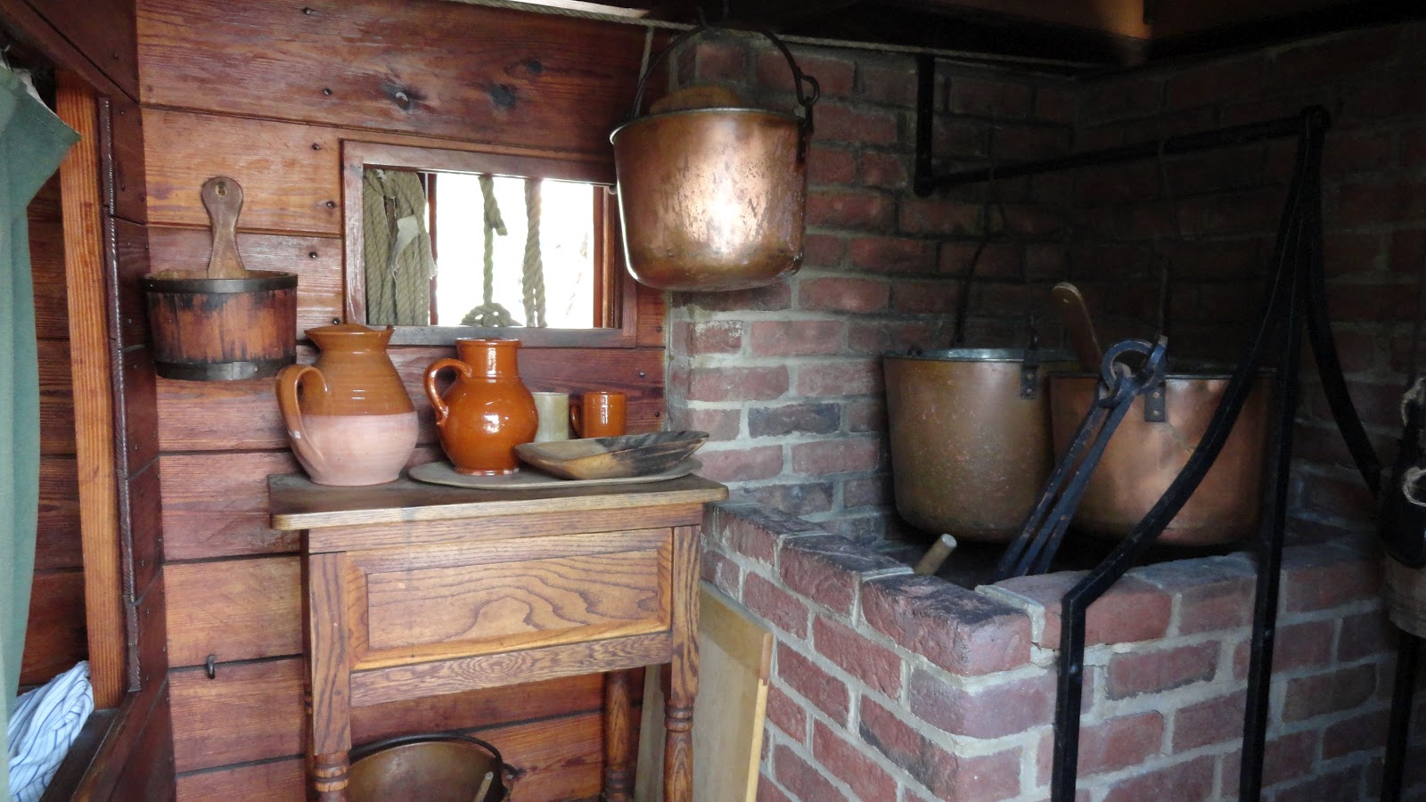
Galley and cook's quarters on board the Susan Constant

Touring the ship was fun. Had I been a crew member back-in-the-day I would have opted to be the cook. He got his own bed in the galley. Not only was it private, but was probably the warmest place on board the ship. It was also not below decks, and given the conditions of travel and lack of hygiene in the 17th century. I think it would have been the best quarters possible. Here, like Williamsburg, the staff was clad in period clothing but wasn't living in the past. They spoke in modern language and were able to answer questions and give presentations that were interesting and easy to follow.

After touring the ships we headed over to where the artillery demonstration was taking place. Honestly, I just had watched a similar demonstration the day before at Colonial Williamburg, and aside from the cannon and a few commands, it wasn't all that different...but really, how does one pass up the opportunity to watch a cannon drill?


Following the drill we made our way to the recreated village. My wife was interested in the garden planted outside the palisaded hamlet. She noted the extremely large rosemary bushes. I busied myself attempting to get a decent picture of the free roaming rooster that was darting here and there...no luck. The bird wouldn't hold still long enough for the shutter to click. So we headed through the gate to have a look around inside the  village.

Typical building style in Jamestown

What struck me was that most of the buildings were rather well built for the period they were trying to recreate. I was expecting log cabins or frame houses made with rough-cut siding. Nope. The earliest of the Jamestown settlers lived in such shelters only long enough to build structures akin to what they were used to back in England. The craftsmen who arrived in the New World were used to constructing Tudor and Elizabethian style buildings, so that's what they built. While some had stone or wood floors, simple dirt was the norm. Still in all. They seemed cozy and well made. Aside from the homes, we toured the storehouse, smithy, armory, and apothecary. In most cases there were interpretive staff members giving demonstrations or lecturing about daily life in early 17th century Virginia.

Inside a Jamestown home

Outside the palisade and a few dozen yards away was the recreated Powhatan village. On display were several huts, lavishly decorated with furs and tools, that would have been commonly found in homes of the indigenous people living there in the early 1600s. Native American lore is a hobby of mine and having led programs on the subject for many years at summer camps, I needed no tour guide as I went from hut to hut. I easily recognized most of the items, albeit I noted the differences between what the Powhatan used and what I was familiar with from the Lenape and Iroquios. Here, arrow quivers were woven from sticks instead of being made from leather. The baskets were differently shaped from what their neighbors to the north used and some of the tools were shaped or sized in a different manner. However the similarities between daily life among the Powhatan and other Eastern Nations were easy to spot. Crops were growing, leather was being stretched and scraped to form it into leather, and people were constructing tools and arrows. 

Pohatan dwelling with cooking rack in foreground

Following our trek through the Powhatan village, we headed back to the welcome center. Before lunch we took in a short film about the construction of the Godspeed replica. Just last year I had watched a wooden ship being built at Mystic Seaport in Connecticut, and the movie made me remember the sights and sounds of a shipyard there. Modern tools were used in both cases, but old techniques and tricks of the trade are still employed in wooden shipmaking. Interesting more was the segment on sailmaking and rigging. I'm not a sailor nor am I a naval buff so I'm easily impressed by those that understand sailing. I was awestruck to see the amount of work and the attention to detail needed to construct canvas sails and rigging. 

Following the film we ate a quick lunch at the welcome center cafeteria. The variety of food was impressive. I opted for a barbecue brisket sandwich, which was pretty good but somewhat overpriced, even for a tourist area. The french fries tasted like typical SYSCO stock. Two lunches with drinks and a small dessert cost us almost $30. Other dining options are quite a drive away, so if you are on a budget I suggest packing a picnic lunch if possible. 

Our afternoon activities lay a short drive away. Just up the road is the National Park Service's Historic Jamestowne (aka Jamestown National Historical Site.) Like most facilities of the NPS, a modest visitor center offers some displays and an orientation film about the area. Outside was something different than any other park I had visited before. For all intents purposes, the place is a full-time archaeological dig. Yes, there are remnants of buildings and a few monuments, but here you can actually see archaeologists working. At the far end of the park, which isn't very large, is the Archaerium, a museum housing the artifacts that have been recovered during the digs. It contains everything from shards of old tools to nearly complete skeletons. The archaeologists come and go from this building as well, often speaking with the staff about the days finds and what's planned for tomorrow. They and the museum staff are quick to answer questions and even show off artifacts. 

Old church at Jamestown National Historical Site

We walked the grounds for some time exploring the old church and looking at the monuments before heading over to watch the afternoon musketeer drill provided by the St. Marie's Citty Militia. The group was small, but demonstrated 17th century pike and musket drills. Like their counterparts at Jamestown Settlement, they too are dressed in period. When one thinks of colonial America images of men in tricorner hats usually comes to mind, these folks looked more like the men on the Dutch Masters' cigar box. Their tactics were of the late Renaissance and they carried matchlock muskets. There was a bit of marching and explanation about drums and flags but the main attraction was the musket drill.


Both parks are well worth seeing. Leave more time for the Settlement. If you are new to living history exhibits, you may need five hours or so if you haven't seen things like a blacksmith or an armorer working a forge before. Even a seasoned historical explorer should leave about four hours, especially if you have  chance to tour the ships or wish to watch the militia. If there is nothing special going on at the National Historic Site, two and half hours should be ample time to visit there. Granted if you want a ranger led activity or wish to see the archaeologists in action, extra time might be needed. Both parks are included if you purchase a Historic Triangle package or you may simply pay the daily entrance fees if Jamestown is your only stop in the area.

The Godspeed under sail on the James River


Friday, June 8, 2012

Virginia's Historic Triangle: Exploring the Birth of America (Part I)

Continental Fifers and Drummers. 
Okay, so not every trip I take involves a hike into the woods or a day sitting in a kayak. I'm a history buff as well and from time to time I like to explore the historic places of America. A springtime trip to Virginia offered me an opportunity to visit Jamestown, Williamsburg, and Yorktown, a trip that would take me from the beginnings of England's colonial attempts in America to its defeat by the descendants of those very first colonists some nearly a century and three quarters later.

My wife and I started our four-day trip to the area with Colonial Williamsburg. We were staying at a Colonial Williamsburg property and after a long drive the previous day, we really didn't feel like getting into the car to visit Jamestown or Yorktown. We opted to walk the short distance from our hotel to the historic area even though we were staying right next to the Visitors' Center where there was a shuttle stop. The sky was cloudless and there was no good reason to be in a vehicle or indoors unless absolutely necessary. Our first stop was the gardens outside Governor's Mansion.

Rows of blooming flowers, hedges, topiaries, and even a maze await garden visitors.
We spent some time exploring the garden area while waiting for performance of the Patrick Henry reenactor to begin. This was an interesting presentation. Like most of the townsfolk here, the players aren't totally immersed into the 18th century. When I visited the Plimouth Plantation in Massachusetts many years ago or have spent time with Revolutionary or Civil War reenactors acknowledgement of anything outside of the time frame in which those personas exist simply didn't happen. Here, at Williamsburg, the people were quite aware of the modern day. "Mr. Henry", in this case, spoke extensively about the goings-on of the colonial period but answered questions about things later in his life and even somewhat into the future. The actor even gave insight into current social and political topics. A sort of "What Would Patrick Henry Do" exercise. It was quite interesting. It made me think of Star Trek: The Next Generation episodes where the crew uses a holodeck to get information from scientists of the past or perspective from historical figures. If only we could really consult with people such as Jefferson, Madison, and Franklin today.

An actor portrays patriot Patrick Henry.
Following our encounter with Mr. Henry, we ambled through the town inspecting several shops and the town armory before taking a lunch break at Shield's Tavern. The menu consisted of items somewhat in the tradition of 18th century colonial America. My "salamagundi" was essentially a chef's salad. I question the commonality of tomatoes as a food in 1780. While some were being cultivated in the Carolinas by then, tomatoes were largely ornamental plants during colonial times. Likewise, we visited in June. A period dish would not have contained tomatoes at all if served at that time of year simply because they aren't in season. I doubt seriously if the colonists grew hot house vegetables. Obviously concessions must be made for the sake of tourism and of course the prices at Shield's Tavern (like all of the Colonial Williamsburg eateries) are adjusted to maximize the outflow of cash from a tourist's wallet as well. I will commend them on the Pea Soup. It was pretty darned good and my wife regretted not ordering just a bowl of it for lunch instead of a cup and a sandwich. Note to the traveler: Eat off property. Had the dining experience been enhanced with period music and had there been actors performing like townspeople of the day discussing politics or gossiping, it might have been worth the price. 
Following lunch we moved to the Great Hopes plantation area for a look into what was done to supply the war effort. This was an interesting demonstration on colonial carpentry and the folks there showed how they made cypress shingles, building timbers, and plank siding. All of the woodcutters and carpenters gave excellent presentations, but it was misnamed. It focused more so on the economics of the building industry during the colonial period rather than how provisions were produced to assist the rebellion. 

Woodworking tools at the Great Hopes plantation area.
We departed the plantation after an hour or so and returned back to the town for the afternoon presentation of "The Revolutionary City." A street-theater production in several acts. The shows vary in subject matter from day-to-day. The weekly program listed some of these events as "The Cause of America" and "A Gale From The North," what is a part of official program and what isn't can be some matter of debate as the program can be confusing. When we were there, the first act dealt with a man who volunteered for the war effort to help earn money for his family. (This was on the weekly program.) Then there were two acts dealing with the war in the west and problems on the home front. (These were on the supplemental program but not on the main weekly schedule.) The performance than drifted to "The Town is Taken!" where turncoat General Benedict Arnold leads redcoats into Williamsburg and hoists the Union Jack over the capitol building. (This is in the weekly program.) The character of Arnold was interesting. The time is 1780 and he has aligned with The Crown. In his speech he explains how he was duped into joining the Rebellion and after several years of sacrificing his health and fortune, realized the futility of the effort. The insight into Arnold was well explored. The act of betrayal is legendary but few people ever get to hear his side of the story. 

Disenfranchised with the Rebellion, Benedict Arnold chastises
the local citizenry when they note his traitorous actions.
Finally, two more acts wrap up the event. (Neither of these were listed on the main schedule either.) Odd though, the "General Reviews the Troops" is listed as a part of the program on the weekly schedule, but not on the supplemental one. A few days after returning from the trip I received an email survey from Colonial Williamsburg that asked, among other things, several questions about "The Revolutionary City" program. I was somewhat critical in my responses because there were so many discrepancies between the daily and weekly schedules. Furthermore, only parts of the presentation had interesting storylines and action. I don't believe any shots were fired as the town was taken, but at least the drill of the Continental troops involved gunpowder!

Trigger time for the Continental troops.

After a quick trip back to our hotel room and an afternoon catnap, we returned to the town for the final event of the day, a concert in capitol. There was an extra cost for this activity but well worth it. The hour-long event featured a string trio comprised of the violin, the harpsichord, and the viola-de-gamba playing songs spanning from the early 17th to later 18th century. The musicians were excellent and the leader of the group was very entertaining with his anecdotes about the music and society of the day.

The Capitol Concert is held in the chambers of the old Virginia House of Burgesses.
Aside from lunch and the issues I had with the printed program, the day was enjoyable. In spite of the fact that everything about Colonial Williamsburg is not 100% accurate and a lot of the buildings are reconstructions, it is a worthwhile place to visit and visitors can learn a lot about life in the 1780s and early American history. The weather was perfect and it was a great way to spend a mid-May day. We headed into town for some dinner and then got a good night sleep in order to be well rested for Jamestown in the morning.

Goodnight, Williamsburg.


http://www.colonialwilliamsburg.com/

http://www.historictriangle.com/


Tuesday, May 8, 2012

History & Adventure Along the Upper Delaware River


A view of Roebling's Delaware Aqueduct from the river

When most people hear the words “Delaware River” it conjures up an image of George Washington standing in a boat, surrounded by ice, while his troops did all the rowing. Let’s flash forward about 230 years and head upriver about 150 miles…oh yeah, and make it summertime. Here, the river cuts through a canopy of green trees, the water is cool and refreshing, and peoples’ interests lie in attacking whitewater rapids, not German mercenaries. Here the river is a place of respite and recreation.

Every summer hundreds of thousands of people flock to the Upper Delaware Scenic & Recreational River for boating, fishing, camping, and wildlife viewing. On any given summer day, rafts, canoes, and kayaks mingle with anglers, swimmers, and spectators on the water and around the shore. With about a half-a-dozen touring companies each with as many bases and campgrounds, about 15 public launches for privately owned boats and off-river based guiding companies, and all the private homes along the river with their own launch areas, one would think the river would be anything but tranquil. Guess again. Anyone with the will and means to make a few small sacrifices can enjoy blissful tranquility on the Delaware just about any day of the summer, even on peak holiday weekends.

Timing is usually the key. Starting a run at 9:00am almost ensures a full two hours of having the river to yourself. Start early and paddle past the crowded campgrounds still waking up from the previous night’s revelry. More times than not, the only other folks on the river this early are fishermen and park rangers. The average start times for most of the people using the commercial outfitters seem to fall between 11am and 1pm. A short 6 mile run means you will be pulling out at 11am and packing up just as the crowds begin to muster. Similarly, postponing your put-in time until after 2:00pm can often mean the crowds are 30-60 minutes ahead of you. Since kayaks and canoes are much faster than river rafts, expect to pass a few of these along the way. Unless the rafts are full of noisy partiers, once you pass them you tend to forget they are even behind you, after all, you are facing downstream.

Rachel Waters from Waymart, PA kayaks frequently on the river
Location is also another important factor. The bulk of the rapids fall between Narrowsburg and Pond Eddy. In fact the elevation change in the 26 miles from Narrowsburg to Pond Eddy is 160 feet, the bulk of it occurring in the first 10 miles. Under the right conditions a paddler at the head of a rapids section can look at another boat only a few hundred feet downstream and actually get a sense of feeling higher than the boat in front. While this area does remain wildly popular, a greater number of starting points are 12 miles south of Narrowsburg, past, what is arguably, the best section of the river.

Pick up a map from the National Park Service before your trip. A number of outfitters offer
kayaks, canoes, and rafts for rental. 
http://www.nps.gov/upde/planyourvisit/boatrentals.htm
If you are venturing on your own, be sure to plan accordingly and check the river
conditions on the hotline: 845-252-7100
The Ten Mile River launch is one of the best places to start a trip down river. It is an easy launch with lots of room for unloading and it is fairly calm, so getting into the water is a breeze. Additionally, directly across the river lie a small set of riffles that can be reached by paddling upstream just a little ways. This is a good place for a novice to give it a try. If you are a first-timer, try the riffles. If it proves to not be for you, paddle back to the shore and it is an easy out. If you continue downstream you will encounter more rapids, each set getting slightly more difficult until reaching the Zane Grey launch in Lackawaxen. Also along this section are some great rock formations that are perfect for a picnic, sunning, or swimming. Between the Kunkeli Rapids and the Zane Grey launch, Minisink Falls drops to the river from the left. You can explore the falls if you can park your boat and if you are willing to make the short trek up to the falls via the tunnel under the highway. 

To get up close and personal with Minisink Falls
means getting out of your boat and venturing through
a concrete conduit
Below Lackawaxen, Cedar Rapids, Stairway Rapids, and Mongaup Rapids also offer some fun. Even these rapids are definitely worth hitting, tacking them on from a launch at Ten Mile means a very long day on the water. Additionally, they are spaced a good distance apart from each other, so there are some monotonous stretches of river, especially at Pond Eddy, in this area. Likewise, the further south you go towards Matamoras, the busier the river gets. For whatever reasons, proportionally more paddlers tend to tackle the Pond Eddy to Matamoras section than they do points further north. 

No matter where you paddle, wildlife sightings are common. Mallard Ducks, Canada Geese, and Common Mergansers can be spotted with little effort. Great Blue Herons and Bald Eagles are almost as common. Aquatic mammals such as Beaver, Otter, and Muskrat are less commonly seen, but no stranger to the river by any means. Similarly, non-aquatic birds such as Tanagers, Blackbirds, Waxwings, and Swallows can all be seen perching along the banks.

Mother Mallard and her ducklings. The Upper Delaware is a great location
for bird watching either in a boat or from the banks

The historians and geologists can also find plenty of things to spark their curiosity along this section of river. Rock formations carved out by eons of rushing water can be explored up and down the banks. Several waterfalls can be seen from the river here as well, most cascading down craggy cliffs from some unknown source far above the river. Old rock quarries dot the landscape. Long abandoned, only piles of rock tailings are left to tell where they once were. These quarries served to provide Bluestone a growing country from the colonial period through the 1930s. A few are still in operation today, but operate on a very large capacity within eyesight of the river. It may be a wild and scenic river now, but at one time this was a highway on industry. Rafts of felled timber floated down this river well into the mid 20th century and along the shores canal boats hauled tons of Anthracite Coal from Scranton to the markets in New York. Remnants of the canal system can still be seen below Lackawaxen where John Roebling was commissioned to build an aqueduct to alleviate canal traffic that crossed over the river (see photo above.) Now a bridge for vehicles, Roebling’s aqueduct still stands today as the oldest suspension bridge in the country. The aqueduct was built just a few hundred yards downstream from the Minisink Ford, a natural low water section in the river, where, two-and-a-half years after Washington made his famous crossing 150 miles downstream, another lesser known figure of the Revolutionary War made his own crossing. Here, in 1779, Joseph Brant, a Mohawk, lead a mixed force of Loyalist militiamen and Iroquois warriors across the river after decisively defeating a contingent of New York militia on the hills just outside of Lackawaxen. History, it seems, is not without a sense of irony. The site of Washington’s crossing is managed by state agencies in Pennsylvania and New Jersey. While it is a National Landmark, this designation is generally considered lesser in precedence than a National River since a landmark may be established by the Secretary of the Interior, whereas a National Scenic and Wild River can only be established by the President or Congress and is managed by the National Park Service.


Please check out these National Park Service webpages prior to your adventure. 


Saturday, April 28, 2012

Tusten Mountain Trail: Upper Delaware Scenic & Recreational River


Looking out from the Tusten Mountain vista.

Most of the Delaware River from northeast Pennsylvania border with New York to just south of the borough of Delaware Water Gap falls under the jurisdiction of the National Park Service. The Upper Delaware Scenic and Recreational River covers the northern section while the Delaware Water Gap National Recreation Area presides over the southern part. In addition to the actual “river” the “Water Gap NRA” has an extensive collection of trails for biking, equestrian use, and hiking. The “Upper Del” is not so fortunate. The vast majority of the land abutting the river is private and hiking opportunities are scarce. There are a few areas of note for woodland ramblers to check out, one of which is the Tusten Mountain Trail.
Located about halfway between Narrowsburg, NY and Lackawaxen, PA, the Tusten Mountain Trail is a three-mile loop that offers a nice view of the valley as well as a wide array of other natural and manmade things to investigate. While not lengthy, it is definitely a moderate hike due to some steep sections as well as some rocky (and in winter, icy) terrain.

Park Service map. Note marks parking area.

The trailhead is rather easy to find. Simply park at the Ten Mile River boat launch and look for the kiosk. Maps for the trail, provided by the Park Service are generally available there. The trail is located on private land owned by the Greater New York Councils of the Boy Scouts of America and is situated within the Ten Mile River Scout Camps approximate 14,000 acres. Several scout tent sites and lean-to areas are located along the trail. Please be respectful of the property and friendly to any scouts or other hikers you may encounter. This area of the scout camp is primarily used for weekend camping by scout troops that are canoeing on the river and for hiking. Additionally some weekday encounters with scouts can be expected in summer as this area is sometimes used by older scouts on multi-day backpacking treks. The campsites are available for use by scouting units, but are not open to the general public.


The trail officially begins at the kiosk and follows the dirt road along the Ten Mile River for a short distance before coming to a stone bridge. The bridge was constructed in 1875 and is a favorite subject for artists and photographers. Immediately after crossing the bridge are some ruins. Reeve’s Mills and Tusten were former villages that used to occupy this area. Here the trail gradually begins its ascent, still following the road for about another 0.4 miles. An abandoned quarry is visible on the right side of the road in this section. Immediately across the road is an old tailings pile from the quarry. Presumably, quarried stone was loaded onto sleds or carts and taken to market; the scrap was pushed to the side and left in piles. This is one of many tailings piles and quarries that dot the entire mountain. After a little bit, the road makes a quick descent. There is a large boulder on the right side of the road and a small vehicle turn-around to the left.


Here, turn right and proceed about 100 feet to a sign-in box. After signing in, hikers can choose to proceed directly to the summit by taking the left fork on the yellow trail or opting for a longer ascent on the red trail. The yellow trail rises sharply with only two short, flat sections. It involves some scrambling near the top. The red trail is rather flat until it meets up with the other part of the yellow loop. From the yellow/red intersection the trail is fairly gradual until it meets the cliff and then it gets rather steep and sketchy. Regardless of which way one takes to the top, crossing through this terrain will be necessary in order to complete the whole loop. Similarly, side trails and intersections can be found no matter if one hikes the loop clockwise, or counter-clockwise. Anyone hiking here should be wary of these side trails as some are not blocked off and a few lead miles away from the area. Others lead to private property and few, if any are marked or show up even on satellite maps.
Some notes attached to the official BSA map for Ten Mile River Scout Reservation.

The summit area has a great vista that overlooks the river. Several large slab rocks are perfect for a picnic or just a quick rest. Immediately below the summit is another old quarry and is worth exploring, but use care. A number of other quarries can be found in the way down from the summit by following the loop clockwise. Anyone hiking the trail in a counter-clockwise manner will encounter the other quarries on the way up.
Wintertime trekkers up Tusten Mountain should be prepared for ice. Snowshoes are not always needed, but boots and some sort of cleat (Yak-Trax, Kahtoolas, etc.) are suggested. Similarly, melting snow can make the trail muddy quite often throughout the winter. Rain runoff and seep make parts very muddy the rest of the year. Boots are not needed in warmer months, but they are not a bad idea.

Turkey and upland game birds are frequently seen in the area. Vultures are a common sight from the vista and eagle watchers should be on the lookout closer to the river. There are a number of Poplar trees in the area as well. Their white blossoms can frequently be seen in the spring along with Bluets, Violets, and Red Columbines. Great Rhododendrons also grow in the area along with Mountain Laurel. Due to the summer canopy, these bushes usually do not bloom. If they do, it is generally later in June and early July. Of course autumn is a wonderful time to explore this trail as well. There is a wide variety of hardwood trees on Tusten Mountain and each yield different hues from late September through the end of October. Although the trail is closed for a two week period during deer hunting season in late November and early December, Tusten Mountain offers something for every hiker year round. 

Tusten Mountain Trail Information: http://www.tusten.org/TustenTrail.htm
Ten Mile River Scout Reservation: http://www.tenmileriver.org/
Upper Delaware Scenic and Recreational River: http://www.nps.gov/upde/index.htm

Mad River Glen: Ski It If You Can


I ski MRG at least once a year and have been doing so for over 10 years. MRG is not a flashy resort with tons of amenities. It does not allow snowboarding. The single-chair lift can have a long line. Trail grooming is minimal. Snowmaking is done by The Almighty. The trails are narrow, steep, and sometimes littered with moguls. These qualities would be a turn-off to most would-be skiers, to MRG devotees, these are the exact reasons this mountain is beloved. In order to appreciate this resort a skier must eschew modernity and embrace skiing as it was before steel framed lodges with drywall interiors, high-speed six-pack lifts, and groomed trails wider than a freeway.

My buddy, Tony riding the Single Chair

 Whether you ride the Single or the fixed-grip double to one of the two top stations, your choices about how to get down are numerous and the difficulty level ranges from a couple of green trails that traverse the resort, to a myriad of straight shots that will have you dodging trees and sketchy sections the whole way. I like to start by warming up on Upper Antelope before cutting over to The Upper Glade, Ferret, or Moody's, and then ski out the Lower Glade. After that, the rest of my day usually is consumed by seeking out trees, chutes, and bumps with occasional journeys into the green terrain when I need a break.

Lower Glades
MRG is not all bumps and trees. In fact, the entire skier's left side of the the lower resort is consumed with oodles of twisting greens and blues reminiscent of a Snakes and Ladders board game. Not only are these fun runs that can be used to access some great off-piste terrain, but these trails are perfect for the kids and beginner skiers. A mid-mountain double serves this area on busier days. Another double serves the somewhat separated learning area. I often wonder what it's like to be a kid here and grow up skiing this mountain. I hope the kids appreciate it.

My friend John, gingerly entering a chute

With no big amenities, there isn't always a lot to do for apres-ski. Good local acts do play in General Stark's Pub. They also serve some excellent dishes and have a nice selection of local brew. Snowshoe trails also exist for those who want something other than skiing.

Lynx trail

 MRG's snowboard ban is perhaps it's most controversial issue. Knowing the history of the resort and the reasoning for it I support the ban to a certain extent, but I know a lot of snowboarders who would love to ride the trails here and are good enough and respectful enough to do so without it being an issue. Instead of snowboarders, MRG attracts a higher-than-usual amount of skiers that use telemark equipment. This anachronistic manner of skiing is just as throwback as the mountain itself, and thus embraced by the resort. It's just another thing that gives MRG a certain flair not found at any other resort, and yet another reason I keep coming back.

Mad River Glen: http://www.madriverglen.com/ (802) 496-3351


The iconic MRG bumper sticker